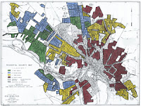
"Redlining," the process of marking off neighborhoods as less desirable, has a long history. According to the "Redlining Richmond" website,
Developers of the Richmond site at the University of Richmond have now combined with the T-RACES project ("Testbed for the Redlining Archives of California's Exclusionary Spaces") at the University of Maryland and researchers at Johns Hopkins University to build "a public-oriented digital archive of federal resources, including maps, demographic data, and contemporary realtor evaluations." Data from this project will be made available on "Mapping Inequality: Redlining in New Deal America" as the maps are completed. More about the larger project is available on the "Big Humanities" website and at Urban Oasis.
Other scholars are also working on GIS-enhanced versions of the HOLC maps. LaDale Winling of Virginia Polytechnic Institute and State University (and blogger at Urban Oasis), has created a website linking to HOLC maps he has worked on digitizing. And Slate recently published a list of on-line sources for redlining maps, as well as a discussion of the role of the HOLC maps.
More commentary and data on redlining can be found around the Web: see, for example, Evan Tachovsky, "The Legacy of Redlining in Rust Belt Cities," and the recent article in Talking Points Memo's "Primary Source" by N.B.D. Connolly on "How did African Americans discover they were being 'redlined'?"
In the late 1930s the Home Owners' Loan Corporation (HOLC), a New Deal agency created to refinance homes and prevent foreclosures, surveyed real estate trends in the nation's largest cities. Working with local lenders and realtors, they assessed neighborhoods using a number of factors ranging from terrain to income levels to the "infiltration of a lower grade population" (by which they meant African Americans, Jews, and immigrants). . . . red "D" areas were "characterized by detrimental influences in a pronounced degree."
Other scholars are also working on GIS-enhanced versions of the HOLC maps. LaDale Winling of Virginia Polytechnic Institute and State University (and blogger at Urban Oasis), has created a website linking to HOLC maps he has worked on digitizing. And Slate recently published a list of on-line sources for redlining maps, as well as a discussion of the role of the HOLC maps.
More commentary and data on redlining can be found around the Web: see, for example, Evan Tachovsky, "The Legacy of Redlining in Rust Belt Cities," and the recent article in Talking Points Memo's "Primary Source" by N.B.D. Connolly on "How did African Americans discover they were being 'redlined'?"
